The Atlanta area has endured a soggy start to 2024, and a new federal forecast shows most Georgians will want to keep their umbrellas handy when the calendar turns to spring.
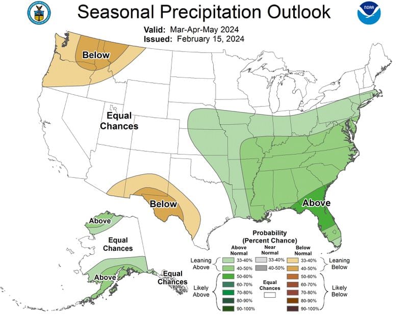
The National Oceanic and Atmospheric Administration’s (NOAA) latest projections released Thursday favor wetter than normal conditions from March through May for most of Georgia, especially in the southern part of the state.
Credit: National Oceanic and Atmospheric Administration
Credit: National Oceanic and Atmospheric Administration
NOAA’s temperature outlook for the next three months in Georgia is less clear. Most of the state has equal chances for above, below or near normal temperatures, but the odds lean slightly toward warmer than average conditions in northeast Georgia.
The agency said the main drivers of the forecast are climate change and the current El Niño.
Global temperatures are rising, mainly due to human activity and the burning of fossil fuels, loading the dice in favor of hotter than normal conditions everywhere on Earth. But in Georgia, El Niño — a phenomenon caused by heat in the tropical Pacific Ocean — typically brings cool, wet weather to the Southern U.S.
Experts say El Niño’s presence is helping tamp down the heat in Georgia, at least for the time being. January in Georgia was cooler than normal, with temperatures averaging 46 degrees, seven-tenths of a degree below the 30-year average.
The rest of the planet, meanwhile, has been sweltering.
Last month, Earth experienced its hottest January in 175 years of record-keeping, with temperatures 2.29 degrees above the 20th-century average. January was the eighth-straight month where global temperatures hit a record high. It was also the second-wettest January on record globally, NOAA said.
In addition to the role played by global warming, what happens in the coming months — and the looming hurricane season — will be dictated by conditions in the Pacific Ocean, said Pam Knox, an agricultural climatologist at the University of Georgia.
The most recent NOAA projections show a transition from El Niño to neutral conditions in the tropical Pacific is likely between April and June. After that, cooler waters are expected to takeover and usher in El Niño’s opposite phase, La Niña. NOAA puts the odds at 55% for La Niña to take hold between June and August.
If the predictions come to pass, it could have major implications for the 2024 hurricane season.
La Niña is known to increase hurricane activity in the Atlantic Basin. And already, sea surface temperatures in the Atlantic Ocean are exceptionally warm — more in line with what’s typical in June or July, not February, Knox said. Ocean heat content is the main source of fuel for hurricanes.
It will be several weeks to months before NOAA and other forecasters make their official predictions for the 2024 hurricane season, but Knox said, “all the ingredients are there for us to have an active season.”
“They (hurricanes) are not necessarily going to pass over us, but it means we may have to be a little bit more prepared than we might otherwise be,” Knox said.
A note of disclosure
This coverage is supported by a partnership with Green South Foundation and Journalism Funding Partners. You can learn more and support our climate reporting by donating at ajc.com/donate/climate/


